|
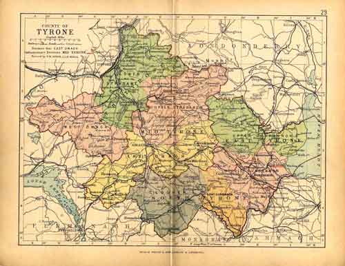
Once again, there is a much larger PDF version available for download HERE (.pdf size: 252kb) You can zoom the pdf quite a bit to see the place names a little better. But, like County Louth's, it's an old map, and the original file wasn't that clear to begin with. Like all of Ireland, County Tyrone has multiple divisions, making it hard sometimes to know what ancestors were referring to. For instance, my father was born in the village of Crannogue, which is in the civil parish of Pomeroy (he was not born in Pomery town as some claim). The civil parish of Pomeroy is in the Poor Law Union of Dungannon. But, then Dungannon is split into three baronies: Upper, Middle and Lower Dungannon. Not only is the civil parish called Pomeroy, but the Roman Catholic Parish is also called Pomeroy, as is the Church of Ireland's, and the Presbtyerian's. The village of Crannogue has all but disappeared on newer maps, and only comes up in Web searches in conjunction with genealogy sites and such. But, it would be in the pink section of Middle Dunganon, right below the "e" in Pomeroy. According to all my son could find out, Crannogue was about 3 miles from the town of Pomeroy. (Close this page to go back...) ©2006 Robert Simmons. All Rights Reserved |